

Locus GIS Offline Land Survey
Use LDPlayer to Play Locus GIS Offline Land Survey on PC
Locus GIS Offline Land Survey is a Productivity application developed by Asamm Software, s. r. o., but with the best Android emulator-LDPlayer, you can download and play Locus GIS Offline Land Survey on your computer.
Running Locus GIS Offline Land Survey on your computer allows you to browse clearly on a large screen, and controlling the application with a mouse and keyboard is much faster than using touchscreen, all while never having to worry about device battery issues.
With multi-instance and synchronization features, you can even run multiple applications and accounts on your PC.
And file sharing makes sharing images, videos, and files incredibly easy.
Download Locus GIS Offline Land Survey and run it on your PC. Enjoy the large screen and high-definition quality on your PC!
Professional GIS application for offline fieldwork with geodata. It provides data collection, viewing, and inspection with support for connection to external GNSS units achieving centimeter accuracy provided by an NTRIP client. All its features are available above a wide selection of online, offline, and WMS/WMTS maps.Fieldwork
• Offline collecting and updating of field data
• Saving points with current location, by location averaging, projection, coordinates, and other methods
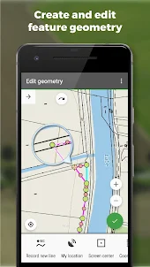
• Creating lines and polygons by motion recording
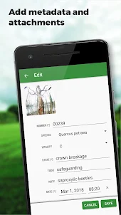
• Settings of attributes
• Photos, video/audio, or drawings as attachments
• Setting out of points
• Boundary delineation
• Collecting location data for polygon/line recording or guidance on a target, even when the app is running in the background
Import/Export
• Importing and editing ESRI SHP files
• Exporting data to ESRI SHP or CSV files
• Exporting whole projects to QGIS
• Support of third-party cloud storage (Dropbox, Google Drive and OneDrive)
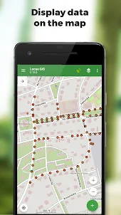
Maps
• Wide range of maps both for online use and for download
• Support of WMS/WMTS sources
• Support of offline maps in MBTiles, SQLite, MapsForge formats, and custom OpenStreetMap data or map themes
Tools and Features
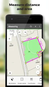
• Measuring distances and areas
• Searching and filtering of data in the attribute table
• Style editing and text labels
• Conditional styling - layer-based unified style or rule-based styling dependent on an attribute value
• Organizing data into layers and projects
• Templates for fast establishing of a project, its layers, and attributes
• Support for over 4200 global and local CRS (e.g. WGS84, ETRS89 Web Mercator, UTM...)
Advanced GNSS Support
• Support for external GNSS receivers for highly precise data collection (Trimble, Emlid, Stonex, ArduSimple, South, TokNav...) and other devices supporting Bluetooth and USB connection
• Skyplot
• NTRIP Client and RTK correction
• GNSS manager for managing receivers, and set up of pole height and antenna phase center
• Accuracy control - setup of minimum tolerance to collect valid data
Form Field Types
• Automatic point numbering
• Text/number
• Date and time
• Checkbox (yes/no)
• Ddrop-down selection with predefined values
• GNSS data (number of satellites, HDOP, PDOP, VDOP, accuracy HRMS, VRMS)
• Attachments: photo, video, audio, file, sketches, map screenshots
Locus GIS is successfully used in a wide range of industries:
Forestry:
• Forest inventory
• Tree mapping and inspections
• Mapping of species groups and vegetation
Environment
• Mapping plants and biotopes, presenting mappings and area delineations
• Faunal surveys, environmental impact assessments, monitoring of species and habitats
• Wildlife studies, plant studies, biodiversity monitoring
Surveying
• Searching for and viewing boundary marks
• Topographic surveys
• Land parcel surveying
Urban Planning and Mapping
• Updating road databases in the public works department
• Mapping and inspections of water pipelines and drainages
• Mapping of urban green spaces and inventory
Agriculture
• Agricultural projects and exploring natural resources, characterizing the soil
• Establishing agricultural land boundaries and identifying plot numbers, districts, and ownership limits
Other ways of use
• Gas and energy distribution
• Planning and construction of wind farms
• Exploration of mining fields and location of wells
• Road construction and maintenance
Screenshots and Videos of Locus GIS Offline Land Survey PC
Why Play Locus GIS Offline Land Survey on PC with LDPlayer?
How to Download Locus GIS Offline Land Survey on PC?
Download and install LDPlayer on your computer
Locate the Play Store in LDPlayer's system apps, launch it, and sign in to your Google account
Enter "Locus GIS Offline Land Survey" into the search bar and search for it
Choose and install Locus GIS Offline Land Survey from the search results
Once the download and installation are complete, return to the LDPlayer home screen
Click on the game icon on the LDPlayer home screen to start enjoying the exciting game
If you've already downloaded the APK file from another source, simply open LDPlayer and drag the APK file directly into the emulator.
If you've downloaded an XAPK file from another source, please refer to the tutorial for installation instructions.
If you've obtained both an APK file and OBB data from another source, please refer to the tutorial for installation instructions.
I have been doing mapping for several decades now. This is by far the greastest little app I have added to my toolbelt in a long time. Took a bit of time to figure out the processes, a manual to view offline would have been helpful. Looking forward to other upgrades and integrations.
An excellent tool for any sort of field work which requires recording spatial data. Very easy to use and very powerful. Points, Lines and Shapes can be added in separate layers on top of your chosen base map in a variety of colours and styles. It is possible to define a list of attributes (like a form) for the individual points/lines/shapes within each layer. This allows the user to record a whole host of user-defined data about each spatial location as well as attaching multiple photos, videos and sketches to each point. Import/Export tools to external GIS programs allow the data to the consolidated and manipulated centrally. The free version comes with full functionality but with a limit of 2 map layers and 3 data layers, whereas the subscription version removes the limit on the number of layers.
The app has big potential. A little bit fighting with UI and understanding all intended features. I would like to utilize two really simple user cases: 1. I am on unknown site and I would like to get and store precise location (with averaging feature and the best with NTRIP server), 2. I would like to drive a stake into the ground for a specific known coordinate (by compass feature with DGPS precision).