GPS Map Camera - Geotag Photo Description
GPS Map Camera - Geotag Photo
Looking for a reliable and easy-to-use GPS map camera app? Look no further than our app! With our app, you can easily capture photos and videos with location information. Plus, our app is designed with your privacy in mind - we don't track any of your data. Whether you're a traveler, a real estate agent, or just want to keep track of your favorite places, our app is the perfect tool for you.
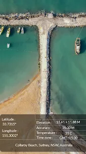
GPS map camera app is a mobile app that allows you to take photos and automatically add GPS coordinates like Latitude, Longitude, Elevation, Accuracy etc to them.
What details you can add on your photo?
- Latitude
- Longitude
- Digital Compass
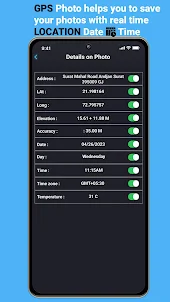
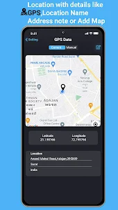
- Address
- Elevation
- Accuracy
- Date
- Day
- Time
- Timezone
- Tempreture
This feature enables users to create a visual map of where they have been and the photos they have taken along the way.
GPS map camera app use GPS technology to check location and add location information to the photos taken by you.
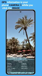
Create your travelling memories of every place you visit with GPS map camera. You can make your photo stamp. Add every details of your location to remember your every trip.
Add Latitude, Longitude, Date and Time, Altitude, Digital compass, Accuracy etc on your photo and save it to your gallery or share it on social media.
If you are traveling or exploring a new area, a GPS map camera app can help you keep track of where you've been and the photos you've taken.
You can track activities such as hiking, camping, and biking, allowing you to track your routes and capture the scenery along the way of your trip.
A geotagging application app allows you to add geographic metadata to your digital content. This metadata can include information such as the latitude and longitude of the location where the content was created, the time and date it was created, and other location-based information.
GPS map camera app can be used by real estate agents and property managers to document properties and their locations.
You can customise what data you want to share on your photo from the setting section. You can turn off which ever you don’t want to show on your photo.
GPS map camera include a compass or direction information, so you can see the direction in which you were facing when you took the photos in your trip.
You can track your current location and weather information when you capture your photos in GPS map camera and geotag photo where you can add gps location.
Why you should use GPS Map Camera?
- You can use geotag photo app to remember every photo you have capture in past.
- While any trip, you can share your current details with the photo with your family member.
- You can store your trip daily with only photos. You don’t need to keep handwritten dairy.
- Get map stamp on your every click in the app
- Geomap stamp and date stamp on your photo to remember dates of every trip
- Longitude, Latitude, elevation, weather, direction, etc on your photo stamp with GPS map camera.
Who can use this app?
- Travellers and explorer who can geotag their photos
- If you are hiking, camping, and biking, allowing you to track your routes and capture the scenery along the way
- Real estate agent and property manager who want to document properties and their locations.
- A person who want to add GPS coordinates details on photo can have this geolocation coordinates app
- A person who want to share location of meetings for any purpose
- Travel blogger or any blogger who want to share location via GPS location stamps
- A person who require precise location data on the photos
We value your privacy and want you to know that we do not track any of your data in our app. You can use our app with confidence knowing that your location and other personal information is safe and secure. Our mission is to provide you with the best GPS map camera experience without compromising your privacy. Thank you for choosing our app…
Looking for a reliable and easy-to-use GPS map camera app? Look no further than our app! With our app, you can easily capture photos and videos with location information. Plus, our app is designed with your privacy in mind - we don't track any of your data. Whether you're a traveler, a real estate agent, or just want to keep track of your favorite places, our app is the perfect tool for you.
GPS map camera app is a mobile app that allows you to take photos and automatically add GPS coordinates like Latitude, Longitude, Elevation, Accuracy etc to them.
What details you can add on your photo?
- Latitude
- Longitude
- Digital Compass
- Address
- Elevation
- Accuracy
- Date
- Day
- Time
- Timezone
- Tempreture
This feature enables users to create a visual map of where they have been and the photos they have taken along the way.
GPS map camera app use GPS technology to check location and add location information to the photos taken by you.
Create your travelling memories of every place you visit with GPS map camera. You can make your photo stamp. Add every details of your location to remember your every trip.
Add Latitude, Longitude, Date and Time, Altitude, Digital compass, Accuracy etc on your photo and save it to your gallery or share it on social media.
If you are traveling or exploring a new area, a GPS map camera app can help you keep track of where you've been and the photos you've taken.
You can track activities such as hiking, camping, and biking, allowing you to track your routes and capture the scenery along the way of your trip.
A geotagging application app allows you to add geographic metadata to your digital content. This metadata can include information such as the latitude and longitude of the location where the content was created, the time and date it was created, and other location-based information.
GPS map camera app can be used by real estate agents and property managers to document properties and their locations.
You can customise what data you want to share on your photo from the setting section. You can turn off which ever you don’t want to show on your photo.
GPS map camera include a compass or direction information, so you can see the direction in which you were facing when you took the photos in your trip.
You can track your current location and weather information when you capture your photos in GPS map camera and geotag photo where you can add gps location.
Why you should use GPS Map Camera?
- You can use geotag photo app to remember every photo you have capture in past.
- While any trip, you can share your current details with the photo with your family member.
- You can store your trip daily with only photos. You don’t need to keep handwritten dairy.
- Get map stamp on your every click in the app
- Geomap stamp and date stamp on your photo to remember dates of every trip
- Longitude, Latitude, elevation, weather, direction, etc on your photo stamp with GPS map camera.
Who can use this app?
- Travellers and explorer who can geotag their photos
- If you are hiking, camping, and biking, allowing you to track your routes and capture the scenery along the way
- Real estate agent and property manager who want to document properties and their locations.
- A person who want to add GPS coordinates details on photo can have this geolocation coordinates app
- A person who want to share location of meetings for any purpose
- Travel blogger or any blogger who want to share location via GPS location stamps
- A person who require precise location data on the photos
We value your privacy and want you to know that we do not track any of your data in our app. You can use our app with confidence knowing that your location and other personal information is safe and secure. Our mission is to provide you with the best GPS map camera experience without compromising your privacy. Thank you for choosing our app…
Open up