Location Assist Description
The LOCATION ASSIST (the App) is a navigational aide implemented as an Android Service aimed at hikers, explorers or boaters that uses received Global Positioning System (GPS) signals to:
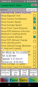
- provide various running and summary statistics of the user’s trip as a label floating on top of other applications. Label can be resized, hidden or re-positioned by the user
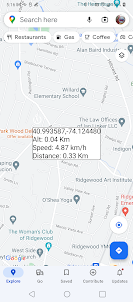
- graphically display a collection of locations the user has been visiting (crumbs)
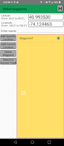
- create waypoints with current or any GPS location and display them on a current track
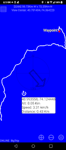
- aide a user to follow a preloaded track or reaching a way point by showing the user’s location and a compass
- playback the current track in the same sequence it was created
It also provides GPX files managing capabilities such as:
- importing external GPX files and converting them into tracks to be displayed and used by the app
- converting user’s tracks into GPX files and vice versa
- sharing user’s GPX files via e-mail, messenger, etc. to be imported into external applications such as Google Maps
(GPX or GPS exchange format, is an XML file format for storing coordinate data. It can store waypoints, tracks, and routes in a way that is easy to process and convert to other forms)
Finally it allows saving trips summaries as text for further viewing and sharing via e-mail, messenger, etc.
The App is especially useful in the areas such as open water or a forest where a traditional map is of a very limited use. The App is implemented as a service so it can keep collecting data even when running in the background. Note that presently the App does not show the map on the track screen – it might be added in the future.
Any combination of the following parameters can be displayed and changed while the App is running.
- Current latitude, longitude and altitude (if altitude reading is available in hardware on your device)
- Difference between current and starting altitude (point-to-point or P2P altitude change)
- Lowest, highest trip altitudes and their difference (altitude range)
- Current elevation angle
- Average elevation angle of the trip
- Current speed over a two dimensional surface (does not account for altitude)
- Current 3-D speed over a three-dimensional surface (accounts for altitude)
- Average speed over a two dimensional surface (does not account for altitude)
- Average 3-D speed over a three-dimensional surface (accounts for altitude)
- Total covered distance over a two dimensional surface (does not account for altitude)
- Total covered 3-D distance over a three dimensional surface (accounts for altitude)
- Straight distance between starting and current point over a two dimensional surface (P2P distance)
- Last and average bearing
- Trip duration (time between the first error-free GPS reading and current time)
The App requests only location access and draw over other applications permissions. The App does not require a cellular connection or a wi-fi signal to operate. Each screen provides an access to the Help files that are embedded into the App. The App has been tested on Android versions 11, 12 and 13. The APP runs on a device that must have a GPS receiver
- provide various running and summary statistics of the user’s trip as a label floating on top of other applications. Label can be resized, hidden or re-positioned by the user
- graphically display a collection of locations the user has been visiting (crumbs)
- create waypoints with current or any GPS location and display them on a current track
- aide a user to follow a preloaded track or reaching a way point by showing the user’s location and a compass
- playback the current track in the same sequence it was created
It also provides GPX files managing capabilities such as:
- importing external GPX files and converting them into tracks to be displayed and used by the app
- converting user’s tracks into GPX files and vice versa
- sharing user’s GPX files via e-mail, messenger, etc. to be imported into external applications such as Google Maps
(GPX or GPS exchange format, is an XML file format for storing coordinate data. It can store waypoints, tracks, and routes in a way that is easy to process and convert to other forms)
Finally it allows saving trips summaries as text for further viewing and sharing via e-mail, messenger, etc.
The App is especially useful in the areas such as open water or a forest where a traditional map is of a very limited use. The App is implemented as a service so it can keep collecting data even when running in the background. Note that presently the App does not show the map on the track screen – it might be added in the future.
Any combination of the following parameters can be displayed and changed while the App is running.
- Current latitude, longitude and altitude (if altitude reading is available in hardware on your device)
- Difference between current and starting altitude (point-to-point or P2P altitude change)
- Lowest, highest trip altitudes and their difference (altitude range)
- Current elevation angle
- Average elevation angle of the trip
- Current speed over a two dimensional surface (does not account for altitude)
- Current 3-D speed over a three-dimensional surface (accounts for altitude)
- Average speed over a two dimensional surface (does not account for altitude)
- Average 3-D speed over a three-dimensional surface (accounts for altitude)
- Total covered distance over a two dimensional surface (does not account for altitude)
- Total covered 3-D distance over a three dimensional surface (accounts for altitude)
- Straight distance between starting and current point over a two dimensional surface (P2P distance)
- Last and average bearing
- Trip duration (time between the first error-free GPS reading and current time)
The App requests only location access and draw over other applications permissions. The App does not require a cellular connection or a wi-fi signal to operate. Each screen provides an access to the Help files that are embedded into the App. The App has been tested on Android versions 11, 12 and 13. The APP runs on a device that must have a GPS receiver
Open up